
Upper Charles Trail Project – Part 2: Design Proposal and Potential Impacts
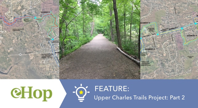
The Upper Charles Trail Committee released their proposed route for the Hopkinton portion of the trail in August 2021.
The above proposed Trail Map contains a total of 11 segments that connect Hopkinton State Park and Legacy Farms via Segment 1 all the way to the Upper Charles Trail parking off Rte 85 at the border of the 3 towns – Hopkinton, Holliston and Milford.
Several ‘sub-projects’ relating to development of these segments are important aspects of the main project and specific segment designs come with their own set of challenges, design considerations and impacts.
A progress report of the project was presented during a public hearing on December 8th.
Source:
Upper Charles Trail Committee hears public comments on trail progress
A few of the segments that have been actively discussed and debated are listed below. They are in different phases of the overall main project.
Campus Trail Connector (Segment 5)
“Campus Trail Connector” was proposed by UCTC as a connecting trail for the Hopkinton High School, Middle School, Hopkins School and the new Marathon Elementary School. On July 29, 2020, The Upper Charles Trail Committee was awarded a MA Trails Grant to undertake engineering studies for the Campus Trail Project.
Estimated Costs
- The grant is for engineering studies only while the estimated cost is about $1 million.
- The State is expected to pay about 80% of this with the Town match consisting of money already spent plus a Community Preservation allocation.
- The estimate was developed in a 2016 Feasibility study and includes a 40% contingency as well as a 25% MassDOT Construction Contingency.
- The design cost estimate amounts to approximately $250K
Sources:
https://uctc.hopkintonma.gov/campus-trail-connector/
Upper Charles Trail Committee receives $111K grant for Campus Trail Connector
Considerations and Impacts
- The ‘Campus Trail Connector’ would provide an easy passage for students, runners, walkers and cyclists between the schools and the downtown area, for a total length of about 2.5 miles.
- The trail would become a significant community facility serving the broader Town community.
- Safety and shared use of facilities – In 2019, members of the School Community expressed support for the Connector along Segment 5. However, the part of the trail (Segment 6) which runs close to the Marathon School raised issues as the town is considering a new school in this area and there are substantial wetlands in the area to be considered.
Video Source: Aerial view explaining the proposed trail starting from the Milford lot moving east
EMC Park – Marathon School (Segment 6)
In Segment 6, which includes EMC Park and Marathon School, UCTC aims to conduct the same level of design as Segment 5 and hopes to receive a MassTrails grant in 2022 to do so. This project is also a direct extension of the ‘Campus Trail Connector’.
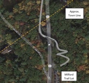
Hayden Rowe Bridge Over 85 (Segment 11)
Updated 2022 Memo from VHB Engineering Consultants
This memo was originally prepared as a draft in 2016 and has recently been updated for the Town’s review. The purpose of this memo is to assist inform the Town in deciding whether or not to pursue a bridge over Hayden Rowe Street.
Estimated Costs
The anticipated cost for the bridge specifically is roughly $500,000. There are additional costs noted in the VHB report for other portions of trail work.
Considerations and Impacts
- Path approaches would be required to connect any bridge superstructure over Hayden Rowe Street.
- Acquisition of private property to construct approaches could be significant depending on the surrounding grades and the method to increase the path profile to the bridge crossing elevation.
- Property acquisition/ permanent easements and temporary easements will be required. (However. property/ abutter relocations do not appear to be required)
- To avoid infringing on private property, it might require a complete overhaul of the street layout.
- Impacts to public utilities including water, sewer, drainage, and overhead utilities such as cable, electric, etc.
- Surface Water Protection Zone (Zone A) is located within this area. Coordination with the local authority (assumed to be the Milford Water District) will be required, which is due to the proximity of Echo Lake.
- The bridge may need to be entirely in Milford (close to the Echo Lake area) to allow the westerly approach to meet ADA (American Disabilities Act), as switchbacks are required to access the bridge from the street.
- Other construction permits relating to Wetlands need to be accounted for.
- Retaining walls will be needed for approaches leading to the main bridge superstructure.
- The height of the shared use path (surface elevation) over Hayden Rowe Street will need to be a minimum of 17-feet to meet AASHTO (American Association of State Highway and Transportation Officials).
Sources:
UCTC divided over trails plan after suggestion of Hayden Rowe ‘realignment’
https://uctc.hopkintonma.gov/bridge-over-route-85/
2016 Memo by VHB Engineering Consultants
Updated Memo by VHB Engineering Consultants
An alternative trail route by the Hopkinton Trails Club was proposed later in response to some of the potential drawbacks regarding specific portions of the Upper Charles Trail (segments 5 to 11). These are detailed in Part 3 of the article – ‘An Alternative Trail Proposal’
Also Read:
Upper Charles Trail Project – Part 1: The Beginnings
Upper Charles Trail Project – Part 3: An Alternative Proposal to Some Sections of the UC Trail
Corrections made to this article on 04/08/2022:
- Hayden Rowe Bridge over 85: The segment at the south end, by the bridge is Segment 11 (previously stated as segment 9 has been corrected to segment 11)
- The anticipated costs for the bridge are roughly $500,000 (previously stated as between $1.2M – $2.0M, but only $500,000 are bridge-specific costs, the remainder are additional costs noted in the VHB report for other portions of trail work)