
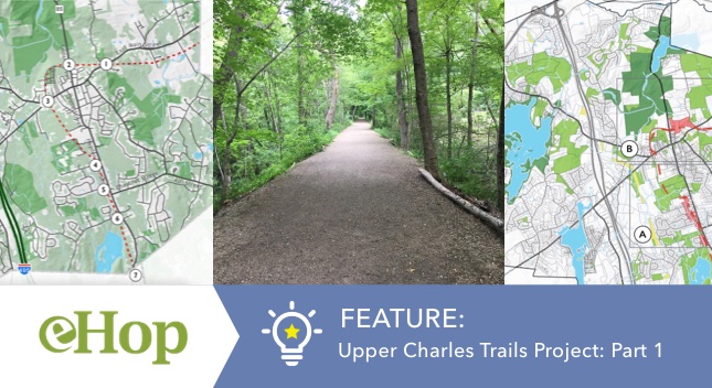
Upper Charles Trail Project – Part 1: The Beginnings
The Beginnings (2012 to 2017)
In 2012, the Upper Charles Trail Committee (UCTC) was established in Hopkinton to plan and develop Hopkinton’s portion of the Upper Charles Trail. This regional trail would eventually link five towns – Hopkinton, Milford, Holliston, Sherborn, Ashland. Hopkinton’s portion will connect to the sections in Milford, which has been completed and Ashland, which is currently in the designing stage.
Roles and Responsibilities of the Upper Charles Trail Committee (UCTC) Project
The UCTC comprises volunteers who are Hopkinton residents and appointed by the Select board. The roles of the UCTC include:
- Planning, design and development of the recreational trail.
- Efforts to acquire or gain access to privately owned sections of the trail.
- Obtain State, Federal grants and other funds to aid trail development.
- Minimizing costs borne by the Town, community and abutter outreach.
Source:
https://uctc.hopkintonma.gov/about-us/
With the above criteria considered, the Committee developed pre-feasibility studies by engaging with VHB, an engineering firm, and laid out several phases for the project. An initial presentation of the studies and future plans were presented to the Selectboard in January of 2017 after an extensive study was done by the Conway School for Sustainable planning and design.
Main goals and Design Considerations for the Upper Charles Trail (UCT) Project
- Integrating Hopkinton’s recreation, conservation, education and economic development by providing connectivity to points of interest, downtown and other local trails. For example, points of interest could include connecting school properties, Hopkinton Center for the Arts, EMC Field Complex and downtown businesses.
- Promote downtown travel via the Main Street multi use path.
The Main Street Connector, which is an important part of this project, therefore relates to the Main Street Corridor/ Downtown revitalization project that includes bike paths, sidewalks and multi-use paths connecting directly to parts of the trail. UCTC worked with Town officials & DOT representatives to create a model, double lane, two way separated bike path and sidewalk. As the center of the Hopkinton community, a pedestrian- and bike-friendly Main Street can simultaneously serve the town’s efforts to revitalize downtown and complete the Upper Charles Trail.
This downtown corridor project and its connections to the center trail is just a small part of the grand vision of this much larger initiative.
Sources:
Bikeable Hopkinton – Upper Charles Trail and Main Street (PAGE 3 of PDF)
UCTC-Presentation-BOS-Jan-2017
Background and History of the Rail Bed
This rail bed originally went through a total of six communities: Framingham, Sherborn, Holliston, Milford, Hopkinton and Ashland. The project to convert the rail bed to the trail was originally conceived by the Conservation Commission as part of the 1993 Holliston Open Space and Recreation Plan and it was the direct result of the vision of John Thomas of Holliston.
Through John Thomas’ vision, it was the town of Holliston to originally seek creation of the bike trail in 1993 with linkages to surrounding towns. The town of Milford was the first to open a complete 5.7 mile section.
The first few pieces of land for the Holliston trail were privately owned, and were either donated or purchased by the town. The first piece of the trail was completed in 2012.
Sources:
Metro West Daily News – Holliston Rail Trail Built Hiking and Biking
MilfordTrail.org – Milford Upper Charles Trail Development History
Rail Trails and Property Values
Several case studies of rail trails on nearby properties indicate a positive impact on property value.
In a study of houses for sale in seven Massachusetts communities near the Minuteman Bikeway and Nashua River Trails, houses located near the trails sold somewhat closer to the list price and much more quickly (29 days on average, compared to 50 days) than other homes in the area (Della Pena).
Sources:
EXPLORING ALTERNATIVES for the Hopkinton Upper Charles Trail (PAGE 19 of PDF)
brucefreemanrailtrail.org/rail-trail-resources/rail-trail-studies/
Some Challenges Identified in 2016
The Conway School for sustainable landscape planning and design provided some insight into trail development challenges in their 2014-2015 study report. The challenges can be broadly categorized into 3 main areas:
I – Property Ownership
- In the strip of rail bed west of Hayden Rowe Street and south of the high school (A), rail bed ownership is distributed among medium-density residential parcels. Fifteen different owners have legal claims over portions of this three-quarter-mile stretch of the rail bed.
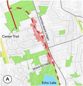
- If Hopkinton chooses to build a trail on the historic rail bed, it would have to negotiate either parcel acquisition or easement agreements with each property owner. This process can be expensive and time consuming, and just one uninterested landowner can obstruct it.
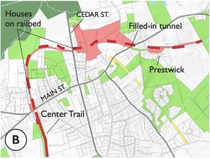
- The parcels that contain portions of the rail bed north of Main Street (B) are varied in their uses. Some stretches have no structures at all, but in some sections residents have built structures over the rail bed. The trail will likely need to leave the rail bed at some points in this section.
- Town Ownership – The Town of Hopkinton owns land closely bordering the rail bed on both sides. The community could make use of this land to develop an off-bed trail where acquisition and easement discussions with private landowners prove challenging.
Source:
Exploring Alternatives for the Hopkinton Upper Charles Trail (PAGE 22-23 of PDF)
II – Road crossings, through streets and neighborhood challenges
In the map below marked 1, 2, 3 and 7 are crossings that will likely necessitate installation of signal lights if a multi-use trail is developed along the rail bed. The heavy traffic flow on Hayden Rowe, Cedar, East and West Main Streets means painted crosswalks would not provide sufficient safety for trail users.
The map marked 1, 2, 3 and 7 are road crossings
Source:
Exploring Alternatives for the Hopkinton Upper Charles Trail (PAGE 20-21 of PDF)
III – Topography, Wetlands, Vegetation and Wildlife
- The existing railbed does not run through any large wetland areas. It does, however, cross over minor intermittent stream beds along its route. To minimize the impact on wetlands, trails can run along boardwalks through wetlands. Boardwalk construction is more expensive than paved trails.
- According to Hopkinton Wetlands Protection Regulations, the construction of impervious surfaces, such as a paved multi-use trail, in watersheds negatively impacts the quantity and quality of stormwater runoff and affects important groundwater characteristics.
- A paved trail may direct surface and stormwater flow patterns away from wetlands and compromise necessary hydrological conditions needed to preserve wetland and the wildlife that inhabit them.
- Trail construction, such as filling, grading, removing vegetation, and creating barriers to movement in resource areas, can severely harm wildlife populations. Some species require continuous woody vegetation between woodland habitat and breeding pools.
Source:
Exploring Alternatives for the Hopkinton Upper Charles Trail (PAGE 26-28 of PDF)
Having worked through the pre-feasibility studies and initial design plans, the committee released their proposed route for the Hopkinton portion of the trail in August 2021.
The above proposed Trail Map contains a total of 11 segments that connect Hopkinton State Park and Legacy Farms via Segment 1 all the way to the Upper Charles Trail parking off Rte 85 at the border of the 3 towns – Hopkinton, Holliston and Milford.
Several ‘sub-projects’ relating to development of these segments are important aspects of the main project and specific segment designs come with their own set of challenges, design considerations and impacts. An alternate trail proposed by the Hopkinton Trails Club is also being evaluated and discussed as a potential candidate for the trail design.
Also Read:
UPPER CHARLES TRAIL PROJECT – PART 2: DESIGN PROPOSAL AND POTENTIAL IMPACTS
Upper Charles Trail Project – Part 3: An Alternative Proposal to Some Sections of the UC Trail